Acanthoceratidae

Acanthoceratidae is an extinct family of acanthoceratoid cephalopods in the order Ammonitida, known from the Upper Cretaceous. The type genus is Acanthoceras.

Acanthoceratidae

Hectonichus · CC BY-SA 3.0 · via Wikipedia/Commons. May be a photograph of a specimen, or an artist’s reconstruction — an interpretation of a skeleton, since colour and soft tissue are almost never preserved.

On record

Recorded, not inferred
Sits inside
AcanthoceratoideaPBDB
Diet
carnivorePBDB, for Ammonoidea
Life habit
nektonicPBDB, for Ammonoidea
Motility
fast-movingPBDB, for Ammonoidea
Vision
well-developedPBDB, for Cephalopoda
Environment
marinePBDB, for Cephalopoda

Time the record covers

At least 20 million years on record.

The record covers at least 110.1 Mya to 89.8 Mya. No occurrence read is dated outside 113.2 Mya to 72.2 Mya.

Early Cretaceous — about 15 of 1880 occurrencesEarly CretaceousLate Cretaceous — about 1865 of 1880 occurrencesLate Cretaceous114–113 Mya — about 0.9 occurrences113–111 Mya — about 2 occurrences111–110 Mya — about 2 occurrences110–108 Mya — about 0.2 occurrences108–107 Mya — about 0.2 occurrences107–105 Mya — about 1 occurrence105–104 Mya — about 2 occurrences104–103 Mya — about 2 occurrences103–101 Mya — about 2 occurrences101–100 Mya — about 140 occurrences100–98 Mya — about 284 occurrences98–97 Mya — about 284 occurrences97–96 Mya — about 284 occurrences96–94 Mya — about 284 occurrences94–93 Mya — about 201 occurrences93–91 Mya — about 186 occurrences91–90 Mya — about 186 occurrences90–88 Mya — about 10 occurrences88–87 Mya — about 3 occurrences87–86 Mya — about 3 occurrences86–84 Mya — about 0.3 occurrences84–83 Mya — about 0.2 occurrences83–81 Mya — about 0.1 occurrences81–80 Mya — about 0.1 occurrences80–78 Mya — about 0.1 occurrences78–77 Mya — about 0.1 occurrences77–76 Mya — about 0.1 occurrences76–74 Mya — about 0.1 occurrences74–73 Mya — about 0.1 occurrences73–71 Mya — about 0.0 occurrences110.1 Mya89.8 Mya114 Mya71.4 Mya

1,880 occurrences of Acanthoceratidae on record, most of them in the Late Cretaceous. Bar height is expected occurrences, not a count: each fossil is spread across the span it is dated to, so a tall narrow bar means tight dating and a low wide one means loose.

When

1,880 occurrences

These are dates about fossils, not the animal: the record can only begin after it arose and end before it died out, so either end may reach further. Shares are expected occurrences: a fossil dated to a span is counted partly in each period it straddles. More on what this infers.

Found in

177 formations

Mancos Shale — 36.35°N, 109.82°WMancos Shale — 35.73°N, 110.82°WMancos Shale — 35.72°N, 106.92°WMancos Shale — 36.14°N, 109.82°WMancos Shale — 36.12°N, 109.91°WMancos Shale — 36.18°N, 110.88°WMancos Shale — 36.16°N, 109.84°WMancos Shale — 36.18°N, 109.88°WMancos Shale — 35.96°N, 110.89°WMancos Shale — 36.53°N, 110.09°WMancos Shale — 36.08°N, 111.07°WMancos Shale — 35.29°N, 107.11°WMancos Shale — 34.74°N, 108.84°WMancos Shale — 34.77°N, 108.78°WMancos Shale — 34.78°N, 108.87°WMancos Shale — 34.44°N, 107.47°WMancos Shale — 35.87°N, 106.91°WMancos Shale — 34.83°N, 108.97°WMancos Shale — 33.89°N, 106.75°WMancos Shale — 36.55°N, 110.48°WMancos Shale — 35.08°N, 107.38°WMancos Shale — 34.44°N, 107.36°WMancos Shale — 34.39°N, 107.27°WMancos Shale — 35.67°N, 106.96°WMancos Shale — 34.26°N, 110.14°WMancos Shale — 35.40°N, 108.95°WMancos Shale — 35.28°N, 108.85°WMancos Shale — 35.12°N, 106.37°WMancos Shale — 34.98°N, 107.10°WMancos Shale — 34.83°N, 107.72°WMancos Shale — 35.13°N, 108.65°WMancos Shale — 33.89°N, 106.75°WMancos Shale — 33.51°N, 106.07°WMancos Shale — 35.51°N, 108.67°WMancos Shale — 35.98°N, 106.90°WMancos Shale — 35.58°N, 106.97°WMancos Shale — 35.55°N, 106.98°WMancos Shale — 35.45°N, 107.12°WMancos Shale — 35.48°N, 106.87°WMancos Shale — 35.26°N, 107.00°WMancos Shale — 35.28°N, 106.94°WMancos Shale — 35.24°N, 106.95°WMancos Shale — 35.23°N, 106.99°WMancos Shale — 34.08°N, 106.65°WMancos Shale — 34.26°N, 106.68°WMancos Shale — 32.76°N, 108.57°WMancos Shale — 32.50°N, 107.70°WMancos Shale — 35.33°N, 105.90°WCotinguiba — 10.76°S, 37.07°WCotinguiba — 10.85°S, 37.17°WCotinguiba — 10.61°S, 36.95°WGreenhorn Limestone — 38.28°N, 104.72°WGreenhorn Limestone — 37.22°N, 103.60°WGreenhorn Limestone — 43.27°N, 103.22°WGreenhorn Limestone — 44.73°N, 103.73°WGreenhorn Limestone — 38.58°N, 98.45°WGreenhorn Limestone — 44.65°N, 103.58°WGreenhorn Limestone — 37.55°N, 104.07°WGreenhorn Limestone — 37.55°N, 104.06°WGreenhorn Limestone — 37.43°N, 104.11°WGreenhorn Limestone — 37.33°N, 104.10°WGreenhorn Limestone — 38.04°N, 101.91°WGreenhorn Limestone — 37.51°N, 102.88°WGreenhorn Limestone — 36.31°N, 104.49°WGreenhorn Limestone — 37.99°N, 103.49°WGreenhorn Limestone — 39.93°N, 105.28°WGreenhorn Limestone — 38.20°N, 104.70°WGreenhorn Limestone — 34.99°N, 103.40°WGreenhorn Limestone — 39.53°N, 97.65°WGreenhorn Limestone — 39.66°N, 97.64°WGreenhorn Limestone — 39.76°N, 97.63°WBelle Fourche — 44.06°N, 104.63°WBelle Fourche — 46.89°N, 108.51°WBelle Fourche — 46.01°N, 108.44°WBelle Fourche — 47.88°N, 108.73°WBelle Fourche — 47.00°N, 107.88°WBelle Fourche — 47.85°N, 108.58°WBelle Fourche — 47.00°N, 108.49°WBelle Fourche — 44.15°N, 104.71°WBelle Fourche — 45.08°N, 104.53°WBelle Fourche — 44.28°N, 104.78°WBelle Fourche — 44.10°N, 104.67°WBelle Fourche — 44.08°N, 106.75°WColorado — 32.76°N, 108.67°WColorado — 32.48°N, 107.72°WColorado — 32.76°N, 108.57°WColorado — 32.72°N, 108.39°WColorado — 32.75°N, 108.46°WColorado — 37.30°N, 108.40°WColorado — 32.87°N, 108.60°WColorado — 32.80°N, 108.40°WColorado — 32.70°N, 108.60°WGreenhorn — 43.27°N, 103.22°WGreenhorn — 40.22°N, 105.27°WGreenhorn — 45.77°N, 96.64°WGreenhorn — 44.05°N, 104.60°WGreenhorn — 32.53°N, 107.70°WGreenhorn — 32.76°N, 108.67°WGreenhorn — 45.02°N, 104.30°WGreenhorn — 37.47°N, 104.11°WGreenhorn — 44.70°N, 103.68°WGreenhorn — 44.74°N, 103.83°WGreenhorn — 38.26°N, 104.73°WGreenhorn — 37.19°N, 104.15°WGreenhorn — 44.15°N, 104.73°WGreenhorn — 32.48°N, 102.72°WTropic Shale — 37.07°N, 111.62°WTropic Shale — 37.29°N, 112.69°WTropic Shale — 37.08°N, 111.66°WTropic Shale — 37.21°N, 111.17°WTropic Shale — 37.58°N, 111.97°WWoodbine — 32.86°N, 97.06°WWoodbine — 33.66°N, 96.45°WWoodbine — 32.77°N, 97.01°WWoodbine — 32.74°N, 97.11°WWoodbine — 32.70°N, 97.45°WWoodbine — 32.99°N, 96.95°WWoodbine — 33.66°N, 96.91°WWoodbine — 33.81°N, 96.83°WWoodbine — 33.68°N, 96.85°WWoodbine — 33.84°N, 95.76°WWoodbine — 33.87°N, 95.57°WCraie de Rouen — 48.60°N, 0.63°ECraie de Rouen — 49.60°N, 0.12°ECraie de Rouen — 48.80°N, 0.00°ECraie de Rouen — 49.08°N, 0.50°ECraie de Rouen — 47.76°N, 0.28°ECraie de Rouen — 49.44°N, 1.09°ECraie de Rouen — 43.80°N, 7.38°ECraie de Rouen — 43.82°N, 6.68°ECraie de Rouen — 43.92°N, 7.02°ELa Luna — 9.83°N, 70.05°WLa Luna — 9.36°N, 71.05°WLa Luna — 10.07°N, 72.60°WLa Luna — 9.45°N, 70.26°WLa Luna — 9.62°N, 70.35°WLa Luna — 9.27°N, 68.77°WLa Luna — 9.65°N, 70.85°WLa Luna — 9.68°N, 69.97°WBeer Head Limestone — 51.08°N, 1.18°EBeer Head Limestone — 50.75°N, 2.33°WBeer Head Limestone — 50.83°N, 2.45°WBeer Head Limestone — 50.77°N, 2.57°WBeer Head Limestone — 50.80°N, 2.67°WBeer Head Limestone — 50.91°N, 0.02°WBeer Head Limestone — 50.83°N, 2.97°WKaskapau — 55.95°N, 122.12°WKaskapau — 55.88°N, 120.00°WKaskapau — 55.92°N, 118.62°WKaskapau — 59.98°N, 119.89°WKaskapau — 56.08°N, 120.17°WKaskapau — 55.88°N, 120.17°WKaskapau — 55.58°N, 121.20°WKaskapau — 54.35°N, 119.82°WKaskapau — 54.14°N, 119.91°WKaskapau — 54.23°N, 119.54°WKaskapau — 54.61°N, 118.46°WKaskapau — 54.88°N, 113.57°WKaskapau — 53.03°N, 117.33°WKaskapau — 52.83°N, 116.08°WKaskapau — 49.59°N, 113.99°WKaskapau — 53.07°N, 117.40°WKaskapau — 55.82°N, 118.37°WFrontier — 43.73°N, 106.76°WFrontier — 42.90°N, 107.44°WFrontier — 41.96°N, 107.31°WFrontier — 43.64°N, 106.65°WFrontier — 42.87°N, 106.59°WFrontier — 43.00°N, 106.86°WFrontier — 43.49°N, 106.51°WFrontier — 43.58°N, 107.96°WFrontier — 43.67°N, 106.63°WFrontier — 45.00°N, 107.53°WFrontier — 44.16°N, 106.78°WFrontier — 43.43°N, 103.55°WFrontier — 45.17°N, 107.72°WFrontier — 45.45°N, 107.62°WKarai — 11.13°N, 79.00°EKarai — 11.20°N, 79.09°EDakota Sandstone — 35.08°N, 106.65°WDakota Sandstone — 34.26°N, 106.68°WDakota Sandstone — 34.29°N, 109.05°WDakota Sandstone — 34.95°N, 107.83°WDakota Sandstone — 34.97°N, 108.67°WDakota Sandstone — 35.48°N, 105.88°WDakota Sandstone — 33.83°N, 109.25°WDakota Sandstone — 34.44°N, 109.80°WLower Chalk — 50.92°N, 2.23°WLower Chalk — 50.83°N, 2.55°WLower Chalk — 50.83°N, 2.60°WLower Chalk — 50.80°N, 2.67°WEagle Ford — 32.70°N, 97.45°WEagle Ford — 32.41°N, 97.21°WEagle Ford — 32.59°N, 97.08°WEagle Ford — 32.51°N, 97.18°WEagle Ford — 31.05°N, 97.47°WChispa Summit — 31.06°N, 105.25°WChispa Summit — 30.80°N, 105.20°WChispa Summit — 30.71°N, 104.77°WGongila — 11.03°N, 11.35°EGongila — 10.94°N, 11.45°EOdukpani — 4.57°N, 6.98°EOdukpani — 5.20°N, 8.25°EOdukpani — 5.22°N, 8.24°EOdukpani — 5.13°N, 8.35°EWest Melbury Marly Chalk — 51.08°N, 1.18°EWest Melbury Marly Chalk — 50.59°N, 1.24°WWest Melbury Marly Chalk — 50.86°N, 0.07°EWest Melbury Marly Chalk — 51.20°N, 2.18°WUnnamed Vocontian — 43.22°N, 5.53°EUnnamed Vocontian — 43.73°N, 6.90°EUnnamed Vocontian — 43.72°N, 7.20°ESanandinovo — 43.56°N, 24.98°EIndidura — 26.42°N, 103.25°WIndidura — 29.35°N, 101.05°WIndidura — 21.93°N, 102.17°W

Loading coastlines…

The named rock units Acanthoceratidae has been recovered from, largest first. Drawn where the rock is now, not where it formed. 153 further formations hold fewer occurrences each and are not listed. 364 occurrences have no formation on record, which is common for older literature.

Acanthoceratidae and its relatives

Late Cretaceous

Where Acanthoceratidae and its relatives were recorded in the Late Cretaceous.

Found in the same rock

806 taxa

The Paleobiology Database records 1,067 sites for Acanthoceratidae, and this reads 240 of them. The number is how many of those sites it was catalogued from too. The 24 sharing the most are listed.

This is not a list of everything alive at the time. It is only what has come out of the same ground as this animal and been written down.

Entered from

234 references

Each of the 1,880 occurrences read was entered from one of these publications, ordered by how many each accounts for. This is not a search for papers mentioning the name. 222 further references are not listed. Entries link to doi.org where the Paleobiology Database holds an identifier, and to its own record where it does not. Relayed as the Paleobiology Database holds them, not checked against what they resolve to.

Media and terms

Media content1
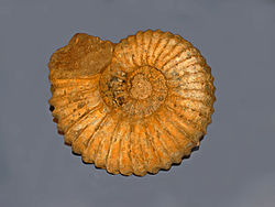
Picture of Acanthoceratidae

Credit
Hectonichus
Licence
CC BY-SA 3.0
Commercial use
the licence allows it

No 3D scan of Acanthoceratidae was found in MorphoSource and Sketchfab.

Smithsonian Open Access was not reached for this taxon, so this list is what the others held rather than everything there is.

The description on this site

Licence
CC BY-SA 4.0

This is what the site found, which is not the same as what exists.

Keep going

Occurrence data from the Paleobiology Database, CC BY 4.0. Grossouvre 1894