Pycnodonte
Pycnodonte is a genus of extinct oysters, fossil marine bivalve mollusks in the family Gryphaeidae, the foam oysters or honeycomb oysters. Shells of species in this genus are found around the world in fossil shell beds from the Valanginian to the Early Pleistocene. They are a commonly found fossil in Cretaceous shellbeds of the Navesink Formation in New Jersey.

Wilson44691 · Public Domain · via Wikipedia/Commons. May be a photograph of a specimen, or an artist’s reconstruction — an interpretation of a skeleton, since colour and soft tissue are almost never preserved.
On record
Recorded, not inferred- Sits inside
- PycnodonteinaePBDB
- Diet
- suspension feederPBDB
- Life habit
- epifaunalPBDB
- Motility
- stationary, attachedPBDB
- Vision
- blindPBDB, for Bivalvia
- Environment
- marine,brackishPBDB, for Ostreida
Time the record covers
At least 132 million years on record.
The record covers at least 132.6 Mya to 129 ka. No occurrence read is dated outside 137.05 Mya to 11.7 ka.
1,123 occurrences of Pycnodonte on record, most of them in the Late Cretaceous. The Paleobiology Database records this as a living group. Bar height is expected occurrences, not a count: each fossil is spread across the span it is dated to, so a tall narrow bar means tight dating and a low wide one means loose.
When
1,123 occurrences- Early Cretaceous1%
- Late Cretaceous63%
- Paleocene10%
- Eocene12%
- Oligocene4%
- Miocene8%
- Pliocene1%
- Pleistoceneunder 1%
These are dates about fossils, not the animal: the record can only begin after it arose and end before it died out, so either end may reach further. Shares are expected occurrences: a fossil dated to a span is counted partly in each period it straddles. More on what this infers.
Found in
206 formations
- Jagüel Formation · Malargüe Group81
- Prairie Bluff Formation · Selma Group80
- Corsicana Marl Formation53
- Vaqueros Formation53
- Roca Formation · Malargüe Group38
- Mancos Shale Formation36
Loading coastlines…
The named rock units Pycnodonte has been recovered from, largest first. Drawn where the rock is now, not where it formed. 182 further formations hold fewer occurrences each and are not listed. 245 occurrences have no formation on record, which is common for older literature.
Pycnodonte and its relatives
Late CretaceousWhere Pycnodonte and its relatives were recorded in the Late Cretaceous.
Found in the same rock
1,290 taxa- Exogyra (Exogyra) costata79 sites
- Turritella66 sites
- Crassatella vadosa61 sites
- Anomia argentaria60 sites
- Idonearca capax60 sites
- Inoceramidae59 sites
- Gryphaeostrea vomer53 sites
- Spondylus53 sites
- Veniella conradi52 sites
- Serpula50 sites
- Exogyra49 sites
- Lucina48 sites
- Crenella serica47 sites
- Cyprimeria47 sites
- Granocardium46 sites
- Nuculana45 sites
- Pseudolimea reticulata45 sites
- Inoceramus44 sites
- Cliona43 sites
- Drepanocheilus43 sites
- Corbula41 sites
- Pterotrigonia (Scabrotrigonia)40 sites
- Camptonectes bubonis37 sites
- Bryozoa36 sites
The Paleobiology Database records 826 sites for Pycnodonte, and this reads 240 of them. The number is how many of those sites it was catalogued from too. The 24 sharing the most are listed.
This is not a list of everything alive at the time. It is only what has come out of the same ground as this animal and been written down.
Entered from
238 references- Molluscs at the K/Pg boundary in Argentina: Extinction and recovery patterns. unpublished Ph.D. thesis96
- Unpublished data on Cretaceous-Paleocene molluscan assemblages89
- Upper Cretaceous (Maestrichtian) Mollusca from the Haustator bilira Assemblage Zone in the East Gulf Coastal Plain78
- The paleoecology of the Cenomanian-Turonian (Cretaceous) stage boundary extinctions at Black Mesa, Arizona69
- Upper Cretaceous (Maestrichtian) larger invertebrate Fossils from the Haustator bilira Assemblage Zone in the west gulf Coastal Plain49
- The Vaqueros Formation, Lower Miocene of California. I. Paleontology44
- Catalogue of the Paleocene and Eocene mollusca of the southern and eastern United States. Part 1. Pelecypoda, Amphineura, Pteropoda, Scaphopoda and Cephalopoda28
- Upper Cretaceous (Maestrichtian) larger invertebrates from the Haustator bilira Assemblage Zone in the Atlantic Coastal Plain with further data for the East Gulf25
- Cretaceous oysters from North Africa : origin and distribution23
- Die Oberkreide der Sack-Mulde bei Alfeld (Cenoman-Unter-Coniac) Lithologie, Biostratigraphie und Inoceramen18
- Cretaceous deposits of the eastern gulf region and species of Exogyra from the eastern gulf region and the Carolinas17
- Stratigraphy of the outcropping post-Magothy Upper Cretaceous formations in Southern New Jersey an Northern Delmarva peninsula, Delaware and Maryland16
Each of the 1,123 occurrences read was entered from one of these publications, ordered by how many each accounts for. This is not a search for papers mentioning the name. 226 further references are not listed. Entries link to doi.org where the Paleobiology Database holds an identifier, and to its own record where it does not. Relayed as the Paleobiology Database holds them, not checked against what they resolve to.
Media and terms
Media content2
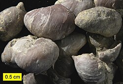
Picture of Pycnodonte
- Source
- Wikipedia/Commons
- Credit
- Wilson44691
- Licence
- Public Domain
- Commercial use
- the licence allows it
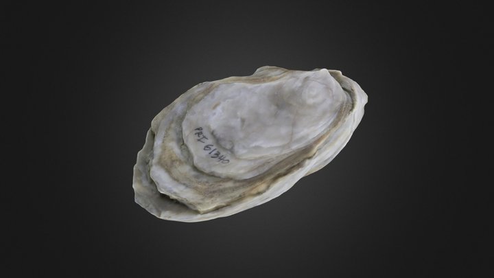
3D model
- Source
- Sketchfab
- Licence
- CC0 Public Domain
- Commercial use
- the licence allows it
The description on this site
- Source
- Wikipedia, “Pycnodonte”
- Licence
- CC BY-SA 4.0
This is what the site found, which is not the same as what exists.
Keep going
What may have been alongside itPycnodonteinae through timeFormations of the Late CretaceousThe world it lived on
Occurrence data from the Paleobiology Database, CC BY 4.0. (Fischer von Waldheim 1835)