Sarcopterygii
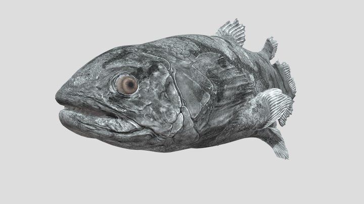
Sarcopterygii is a clade of vertebrate animals which includes a group of bony fishes and all four legged land animals, including humans. The common name for this clade is lobe-finned fish.

User:ArthurWeasley User:Bruce A.S.Henderson User:Mitch Ames User:DiBgd · CC BY-SA 4.0 · via Wikipedia/Commons. May be a photograph of a specimen, or an artist’s reconstruction — an interpretation of a skeleton, since colour and soft tissue are almost never preserved.
On record
Recorded, not inferred- Also called
- lobe-finned fishPBDB
- Sits inside
- OsteichthyesPBDB
- Motility
- actively mobilePBDB, for Osteichthyes
Time the record covers
At least 438 million years on record.
The record covers at least 438.6 Mya to 11.7 ka. No occurrence read is dated outside 443.1 Mya to 0 Mya.
12,000+ occurrences of Sarcopterygii on record. The Paleobiology Database records this as a living group. Bar height is expected occurrences, not a count: each fossil is spread across the span it is dated to, so a tall narrow bar means tight dating and a low wide one means loose.
When
12,000 occurrences read- Silurianunder 1%
- Devonianunder 1%
- Carboniferousunder 1%
- Permianunder 1%
- Early Triassicunder 1%
- Middle Triassicunder 1%
- Late Triassicunder 1%
- Early Jurassicunder 1%
- Late Jurassicunder 1%
- Early Cretaceousunder 1%
- Late Cretaceous12%
- Paleocene34%
- Eocene47%
- Oligoceneunder 1%
- Miocene3%
- Plioceneunder 1%
- Pleistoceneunder 1%
- Holoceneunder 1%
These are dates about fossils, not the animal: the record can only begin after it arose and end before it died out, so either end may reach further. Shares are expected occurrences: a fossil dated to a span is counted partly in each period it straddles. The read hit its cap, so every figure above is a floor and the shares are of the occurrences read. More on what this infers.
Found in
at least 252 formations
- Willwood Formation2,701
- Fort Union Formation965
- Wasatch Formation870
- DeBeque Formation744
- Wind River Formation677
- Hell Creek Formation · Montana Group622
Loading coastlines…
The named rock units Sarcopterygii has been recovered from, largest first. Drawn where the rock is now, not where it formed. The read hit its cap, so each count is a floor. 228 further formations hold fewer occurrences each and are not listed. 1,571 occurrences have no formation on record, which is common for older literature.
Found in the same rock
2,465 taxa- Reptilia12 sites
- Dinosauria11 sites
- Theropoda9 sites
- Crocodylia8 sites
- Kuehneosaurus8 sites
- Anguini7 sites
- Diphydontosaurus7 sites
- Osteichthyes7 sites
- Placosaurus7 sites
- Testudines7 sites
- Thyrohyrax domorictus7 sites
- Albertosaurus sarcophagus6 sites
- Amphisbaenidae6 sites
- Anthozoa6 sites
- Anura6 sites
- Archosauria6 sites
- Cadurcogekko piveteaui6 sites
- Gastropoda6 sites
- Necrosaurus cayluxi6 sites
- Planocephalosaurus robinsonae6 sites
- Plesiolacerta lydekkeri6 sites
- Pseudolacerta mucronata6 sites
- Pterosauria6 sites
- Rotularia6 sites
The Paleobiology Database records at least 560 sites for Sarcopterygii, and this reads 240 of them. The number is how many of those sites it was catalogued from too. The 24 sharing the most are listed.
This is not a list of everything alive at the time. It is only what has come out of the same ground as this animal and been written down.
Entered from
at least 787 references- Synonymies and reidentifications of North American fossil mammals1,544
- Faunal Zonation of the Willwood Formation in the Central Bighorn Basin, Wyoming811
- The Clarkforkian Land-Mammal Age and Mammalian Faunal Composition Across the Paleocene-Eocene Boundary762
- Early Eocene Mammalian Fauna of the Piceance Creek Basin. Northwestern Colorado488
- The Bug Creek problem and the Cretaceous-Tertiary transition at McGuire Creek, Montana277
- Revision of the Wind River faunas, early Eocene of central Wyoming. Part 13. Systematics and phylogenetic pattern of early Eocene Hyopsodus (Mammalia: Condylarthra)229
- Paleocene vertebrate paleontology of the San Juan Basin, New Mexico206
- Distribution and stratigraphic correlation of upper Paleocene and lower Eocene fossil mammal and plant localities of the Fort Union, Willwood, and Tatman formations, southern Bighorn Basin, Wyoming199
- Systematics and Evolution of Early Eocene Hyaenodontidae (Mammalia, Creodonta) in the Clarks Fork Basin, Wyoming187
- Ancestry and Species Definition in Paleontology: A Stratocladistic Analysis of Paleocene-Eocene Viverravidae (Mammalia, Carnivora) from Wyoming179
- Revision of the Wind River faunas, early Eocene of central Wyoming. Part 5. Geology and biostratigraphy of the upper part of the Wind River Formation, northeastern Wind River Basin175
- Systematics and Evolution of Early Eocene Perissodactyla (Mammalia) in the Clarks Fork Basin, Wyoming164
Each of the 12,000 occurrences read was entered from one of these publications, ordered by how many each accounts for. This is not a search for papers mentioning the name. That read hit its cap, so each count is a floor. 775 further references are not listed. Entries link to doi.org where the Paleobiology Database holds an identifier, and to its own record where it does not. Relayed as the Paleobiology Database holds them, not checked against what they resolve to.
Media and terms
Media content2

Picture of Sarcopterygii
- Source
- Wikipedia/Commons
- Credit
- User:ArthurWeasley User:Bruce A.S.Henderson User:Mitch Ames User:DiBgd
- Licence
- CC BY-SA 4.0
- Commercial use
- the licence allows it
Smithsonian Open Access and MorphoSource were not reached for this taxon, so this list is what the others held rather than everything there is.
The description on this site
- Licence
- CC BY-SA 4.0
This is what the site found, which is not the same as what exists.
Keep going
What may have been alongside itOsteichthyes through timeThe world it lived on
Occurrence data from the Paleobiology Database, CC BY 4.0. (Romer 1955)