Carditidae

Carditidae is a family of marine bivalve clams of the order Carditida, which was long included in the Venerida. They are the type taxon of the superfamily Carditoidea.

Carditidae

W.H.Baily · Public Domain · via Wikipedia/Commons. May be a photograph of a specimen, or an artist’s reconstruction — an interpretation of a skeleton, since colour and soft tissue are almost never preserved.

On record

Recorded, not inferred
Sits inside
CrassatelloideaPBDB
Diet
suspension feederPBDB
Life habit
infaunalPBDB
Motility
facultatively mobilePBDB
Vision
blindPBDB, for Crassatelloidea
Environment
marinePBDB, for Crassatelloidea

Time the record covers

At least 246 million years on record.

The record covers at least 247 Mya to 11.7 ka. No occurrence read is dated outside 248.6 Mya to 0 Mya.

Permian — about 0 of 4402 occurrencesEarly Triassic — about 1 of 4402 occurrencesMiddle Triassic — about 1 of 4402 occurrencesLate Triassic — about 79 of 4402 occurrencesLate TriassicEarly Jurassic — about 63 of 4402 occurrencesEarly JurassicMiddle Jurassic — about 0 of 4402 occurrencesLate Jurassic — about 6 of 4402 occurrencesEarly Cretaceous — about 58 of 4402 occurrencesEarly CretaceousLate Cretaceous — about 295 of 4402 occurrencesLate CretaceousPaleocene — about 579 of 4402 occurrencesEocene — about 1420 of 4402 occurrencesEoceneOligocene — about 294 of 4402 occurrencesMiocene — about 776 of 4402 occurrencesPliocene — about 347 of 4402 occurrencesPleistocene — about 466 of 4402 occurrences254–245 Mya — about 1 occurrence245–237 Mya — about 2 occurrences237–228 Mya — about 19 occurrences228–220 Mya — about 13 occurrences220–211 Mya — about 12 occurrences211–203 Mya — about 26 occurrences203–194 Mya — about 25 occurrences194–186 Mya — about 35 occurrences186–178 Mya — about 9 occurrences178–169 Mya — about 0.8 occurrences169–161 Mya — about 0.1 occurrences161–152 Mya — about 3 occurrences152–144 Mya — about 3 occurrences144–135 Mya — about 1 occurrence135–127 Mya — about 3 occurrences127–118 Mya — about 14 occurrences118–110 Mya — about 19 occurrences110–101 Mya — about 19 occurrences101–93 Mya — about 35 occurrences93–85 Mya — about 13 occurrences85–76 Mya — about 21 occurrences76–68 Mya — about 172 occurrences68–59 Mya — about 493 occurrences59–51 Mya — about 375 occurrences51–42 Mya — about 449 occurrences42–34 Mya — about 741 occurrences34–25 Mya — about 225 occurrences25–17 Mya — about 353 occurrences17–8.5 Mya — about 395 occurrences8.5–0 Mya — about 925 occurrences247 Mya11.7 ka254 Mya0 Mya

4,402 occurrences of Carditidae on record, most of them in the Eocene. The Paleobiology Database records this as a living group. Bar height is expected occurrences, not a count: each fossil is spread across the span it is dated to, so a tall narrow bar means tight dating and a low wide one means loose.

When

4,402 occurrences

These are dates about fossils, not the animal: the record can only begin after it arose and end before it died out, so either end may reach further. Shares are expected occurrences: a fossil dated to a span is counted partly in each period it straddles. More on what this infers.

Found in

654 formations

Kincaid — 31.28°N, 96.98°WKincaid — 29.88°N, 97.67°WKincaid — 30.08°N, 97.50°WKincaid — 31.67°N, 96.47°WKincaid — 30.33°N, 97.37°WKincaid — 31.17°N, 96.83°WKincaid — 29.33°N, 98.98°WKincaid — 31.52°N, 96.53°WKincaid — 32.98°N, 95.93°WKincaid — 32.43°N, 96.22°WKincaid — 29.75°N, 97.77°WKincaid — 29.38°N, 99.02°WKincaid — 33.13°N, 96.10°WKincaid — 32.57°N, 96.17°WKincaid — 32.58°N, 96.30°WKincaid — 29.16°N, 99.57°WKincaid — 29.33°N, 99.28°WKincaid — 28.71°N, 100.50°WKincaid — 30.23°N, 97.52°WKincaid — 28.53°N, 100.23°WKincaid — 28.74°N, 100.35°WKincaid — 28.44°N, 100.25°WKincaid — 29.39°N, 99.06°WKincaid — 29.21°N, 99.79°WKincaid — 31.41°N, 96.57°WKincaid — 31.31°N, 96.63°WKincaid — 29.75°N, 97.87°WKincaid — 29.57°N, 97.96°WKincaid — 30.11°N, 97.32°WKincaid — 30.00°N, 97.69°WKincaid — 29.35°N, 99.14°WKincaid — 31.05°N, 96.83°WKincaid — 31.55°N, 96.63°WKincaid — 31.29°N, 96.72°WKincaid — 30.35°N, 97.35°WKincaid — 30.78°N, 96.46°WMoodys Branch — 32.85°N, 90.41°WMoodys Branch — 32.95°N, 90.17°WMoodys Branch — 32.23°N, 92.15°WMoodys Branch — 32.01°N, 92.00°WMoodys Branch — 32.33°N, 90.15°WMoodys Branch — 31.88°N, 88.69°WMoodys Branch — 31.88°N, 88.32°WMoodys Branch — 31.54°N, 87.52°WMoodys Branch — 31.67°N, 92.89°WMoodys Branch — 33.96°N, 92.19°WMoodys Branch — 35.01°N, 90.79°WMoodys Branch — 31.97°N, 88.53°WMoodys Branch — 32.17°N, 88.83°WMoodys Branch — 31.26°N, 93.82°WMoodys Branch — 32.11°N, 92.08°WMoodys Branch — 32.98°N, 90.30°WCook Mountain — 31.29°N, 86.56°WCook Mountain — 31.31°N, 86.48°WCook Mountain — 30.53°N, 96.69°WCook Mountain — 31.75°N, 92.97°WCook Mountain — 32.35°N, 92.72°WCook Mountain — 32.32°N, 89.03°WCook Mountain — 32.04°N, 88.73°WCook Mountain — 32.10°N, 88.86°WCook Mountain — 31.54°N, 87.52°WCook Mountain — 32.00°N, 89.00°WCook Mountain — 32.44°N, 89.11°WCook Mountain — 32.50°N, 93.05°WCook Mountain — 31.76°N, 93.09°WCook Mountain — 31.36°N, 96.14°WCook Mountain — 32.17°N, 88.83°WCook Mountain — 32.14°N, 89.00°WCook Mountain — 32.32°N, 89.16°WCook Mountain — 31.35°N, 95.51°WCook Mountain — 31.32°N, 95.46°WCook Mountain — 31.88°N, 92.96°WCook Mountain — 31.12°N, 95.90°WCook Mountain — 31.20°N, 95.73°WCook Mountain — 31.25°N, 95.72°WCook Mountain — 29.95°N, 97.14°WCook Mountain — 30.63°N, 96.55°WCook Mountain — 30.63°N, 96.54°WCook Mountain — 31.11°N, 96.28°WCook Mountain — 31.36°N, 95.42°WCook Mountain — 30.07°N, 97.08°WHatchetigbee Bluff — 31.58°N, 86.74°WHatchetigbee Bluff — 32.08°N, 88.22°WHatchetigbee Bluff — 31.92°N, 87.97°WHatchetigbee Bluff — 31.45°N, 85.63°WHatchetigbee Bluff — 31.40°N, 85.13°WHatchetigbee Bluff — 31.07°N, 88.03°WHatchetigbee Bluff — 32.37°N, 88.68°WHatchetigbee Bluff — 31.93°N, 88.05°WHatchetigbee Bluff — 31.35°N, 86.08°WHatchetigbee Bluff — 32.25°N, 88.43°WHatchetigbee Bluff — 31.93°N, 87.75°WHatchetigbee Bluff — 31.97°N, 87.86°WHatchetigbee Bluff — 31.65°N, 88.08°WHatchetigbee Bluff — 31.91°N, 87.74°WHatchetigbee Bluff — 31.94°N, 84.70°WGosport Sand — 31.52°N, 87.90°WGosport Sand — 31.54°N, 87.52°WGosport Sand — 31.50°N, 87.80°WGosport Sand — 31.57°N, 87.58°WGosport Sand — 31.53°N, 87.57°WGosport Sand — 31.13°N, 87.93°WGosport Sand — 31.57°N, 88.04°WGosport Sand — 31.73°N, 87.89°WLisbon — 31.53°N, 87.60°WLisbon — 31.84°N, 88.25°WLisbon — 31.50°N, 87.80°WLisbon — 31.76°N, 88.10°WLisbon — 31.87°N, 88.32°WLisbon — 31.30°N, 86.48°WLisbon — 31.70°N, 88.28°WLisbon — 31.32°N, 86.73°WLisbon — 31.54°N, 87.52°WLisbon — 31.82°N, 88.24°WLisbon — 31.55°N, 87.91°WCorsicana Marl — 33.15°N, 96.04°WCorsicana Marl — 32.86°N, 96.21°WCorsicana Marl — 32.76°N, 96.28°WCorsicana Marl — 32.25°N, 96.29°WCorsicana Marl — 32.06°N, 96.47°WCorsicana Marl — 31.82°N, 96.54°WCorsicana Marl — 31.74°N, 96.61°WCorsicana Marl — 31.75°N, 96.61°WCorsicana Marl — 31.52°N, 96.58°WCorsicana Marl — 31.40°N, 96.73°WCorsicana Marl — 30.94°N, 96.95°WCorsicana Marl — 30.81°N, 97.10°WCorsicana Marl — 30.38°N, 97.49°WCorsicana Marl — 30.37°N, 97.45°WCorsicana Marl — 30.30°N, 97.46°WCorsicana Marl — 30.23°N, 97.52°WCorsicana Marl — 30.19°N, 97.57°WCorsicana Marl — 29.95°N, 97.71°WCorsicana Marl — 29.83°N, 97.84°WCorsicana Marl — 29.49°N, 98.19°WCorsicana Marl — 29.44°N, 98.56°WCorsicana Marl — 31.30°N, 96.90°WWeches — 30.50°N, 96.63°WWeches — 31.57°N, 93.48°WWeches — 31.25°N, 96.12°WWeches — 31.59°N, 94.82°WWeches — 30.23°N, 97.52°WWeches — 31.56°N, 94.50°WWeches — 30.68°N, 96.58°WWeches — 31.21°N, 96.02°WWeches — 31.11°N, 96.28°WWeches — 31.53°N, 94.41°WWeches — 31.34°N, 95.68°WWeches — 31.35°N, 95.68°WWeches — 31.00°N, 96.83°WWeches — 30.01°N, 97.16°WWeches — 31.22°N, 96.06°WNanjemoy — 37.52°N, 76.79°WNanjemoy — 37.67°N, 77.19°WNanjemoy — 37.64°N, 77.20°WNanjemoy — 37.93°N, 77.35°WNanjemoy — 38.15°N, 77.18°WNanjemoy — 38.23°N, 77.30°WNanjemoy — 38.34°N, 77.19°WNanjemoy — 37.77°N, 77.33°WNanjemoy — 38.06°N, 77.38°WNanjemoy — 38.23°N, 77.39°WNanjemoy — 38.03°N, 76.84°WNanjemoy — 38.19°N, 77.23°WNanjemoy — 38.03°N, 77.35°WNanjemoy — 38.34°N, 77.28°WNanjemoy — 38.51°N, 77.02°WNanjemoy — 38.70°N, 76.97°WNanjemoy — 38.40°N, 76.99°WNanjemoy — 38.52°N, 77.10°WNanjemoy — 38.82°N, 76.75°WTuscahoma — 31.70°N, 84.85°WTuscahoma — 31.82°N, 87.37°WTuscahoma — 31.83°N, 87.53°WTuscahoma — 32.08°N, 88.22°WTuscahoma — 31.33°N, 85.58°WTuscahoma — 31.85°N, 87.95°WTuscahoma — 31.85°N, 87.53°WTuscahoma — 32.06°N, 88.11°WTuscahoma — 31.54°N, 87.52°WJagüel — 38.13°S, 68.41°WWills Point — 30.17°N, 97.46°WWills Point — 30.08°N, 97.50°WWills Point — 30.27°N, 97.73°WWills Point — 30.10°N, 97.30°WWills Point — 29.57°N, 98.68°WWills Point — 30.33°N, 97.37°WWills Point — 31.17°N, 96.83°WWills Point — 29.47°N, 98.17°WWills Point — 29.38°N, 99.02°WWills Point — 29.38°N, 99.05°WWills Point — 30.52°N, 97.37°WWills Point — 29.28°N, 98.61°WWills Point — 29.57°N, 97.90°WWills Point — 28.71°N, 100.50°WYorktown — 37.22°N, 76.93°WYorktown — 37.23°N, 76.96°WYorktown — 35.51°N, 77.62°WYorktown — 37.10°N, 76.39°WYorktown — 37.17°N, 76.77°WYorktown — 37.51°N, 77.21°WYorktown — 37.25°N, 76.50°WYorktown — 37.27°N, 76.57°WYorktown — 34.90°N, 78.05°WYorktown — 37.21°N, 76.69°WYorktown — 37.06°N, 76.63°WYorktown — 37.15°N, 76.74°WYorktown — 35.15°N, 77.14°WClayton — 31.83°N, 86.62°WClayton — 31.90°N, 86.88°WClayton — 30.71°N, 84.86°WClayton — 31.90°N, 87.07°WClayton — 31.99°N, 87.29°WClayton — 32.12°N, 87.26°WClayton — 31.89°N, 84.80°WClayton — 31.72°N, 86.26°WClayton — 31.98°N, 87.22°WClayton — 31.99°N, 87.13°WClayton — 31.98°N, 86.97°WClayton — 37.18°N, 89.07°WClayton — 32.05°N, 86.78°WClayton — 34.73°N, 88.95°WClayton — 34.49°N, 89.01°WClayton — 32.24°N, 84.31°WClayton — 35.06°N, 88.89°WPorters Creek — 31.90°N, 86.88°WPorters Creek — 31.93°N, 87.02°WPorters Creek — 32.12°N, 87.26°WPorters Creek — 31.99°N, 87.29°WPorters Creek — 31.98°N, 87.13°WPorters Creek — 32.20°N, 87.76°WPorters Creek — 32.12°N, 87.57°WPorters Creek — 32.03°N, 87.45°WPorters Creek — 31.97°N, 87.20°WPorters Creek — 32.23°N, 88.00°WPorters Creek — 31.98°N, 86.97°WPorters Creek — 30.33°N, 87.00°WPorters Creek — 31.94°N, 87.05°WPorters Creek — 35.06°N, 88.89°WTallahatta — 31.53°N, 86.70°WTallahatta — 32.08°N, 88.22°WTallahatta — 31.92°N, 87.97°WTallahatta — 31.37°N, 86.52°WTallahatta — 31.30°N, 86.48°WTallahatta — 31.30°N, 86.55°WChipola — 30.57°N, 85.84°WChipola — 30.44°N, 85.19°WChipola — 30.43°N, 84.98°WChipola — 30.59°N, 84.58°WChipola — 30.33°N, 82.76°WChipola — 30.47°N, 84.99°WWaccamaw — 34.33°N, 78.20°WWaccamaw — 34.29°N, 78.51°WWaccamaw — 34.23°N, 77.94°WWaccamaw — 34.56°N, 78.49°WWaccamaw — 34.07°N, 78.27°WWaccamaw — 34.21°N, 81.31°WWaccamaw — 33.97°N, 78.39°WWaccamaw — 34.17°N, 78.60°WWaccamaw — 33.86°N, 78.55°WWaccamaw — 33.63°N, 79.16°WWaccamaw — 33.40°N, 79.25°WTimms Point Silt — 33.73°N, 118.28°WTimms Point Silt — 33.78°N, 118.35°WLefipán — 42.67°S, 69.98°WLefipán — 42.83°S, 69.70°WLefipán — 42.74°S, 69.61°WCaloosahatchee — 25.91°N, 81.36°WCaloosahatchee — 26.89°N, 82.01°WCaloosahatchee — 26.76°N, 81.14°WCaloosahatchee — 26.34°N, 80.86°WCaloosahatchee — 27.77°N, 82.68°WCaloosahatchee — 27.34°N, 82.42°WCaloosahatchee — 26.76°N, 81.46°WCaloosahatchee — 26.96°N, 81.17°WCaloosahatchee — 26.75°N, 80.93°WCaloosahatchee — 26.96°N, 81.99°WPirabas — 0.80°S, 47.13°WPirabas — 1.00°S, 48.00°WPirabas — 1.23°S, 47.40°WPirabas — 0.74°S, 47.32°WPirabas — 0.48°S, 48.17°WPirabas — 1.05°S, 47.16°WPirabas — 0.60°S, 47.31°WPirabas — 2.58°S, 43.38°WPirabas — 1.66°S, 45.37°WOmagari — 42.83°N, 143.67°EProvidence — 31.91°N, 86.17°WProvidence — 31.97°N, 86.00°WProvidence — 31.92°N, 85.82°WProvidence — 31.89°N, 85.70°WProvidence — 31.95°N, 85.68°WProvidence — 31.92°N, 85.35°WProvidence — 31.94°N, 86.11°WProvidence — 31.84°N, 85.22°WProvidence — 31.75°N, 85.12°WProvidence — 31.80°N, 85.00°WProvidence — 31.96°N, 85.45°WProvidence — 31.89°N, 85.21°W

Loading coastlines…

The named rock units Carditidae has been recovered from, largest first. Drawn where the rock is now, not where it formed. 630 further formations hold fewer occurrences each and are not listed. 742 occurrences have no formation on record, which is common for older literature.

Carditidae and its relatives

Eocene

Where Carditidae and its relatives were recorded in the Eocene.

Found in the same rock

2,266 taxa

The Paleobiology Database records at least 1,359 sites for Carditidae, and this reads 240 of them. Of that, one read hit the database's own return limit, so every count below is a floor rather than a total. The number is how many of those sites it was catalogued from too. The 24 sharing the most are listed.

This is not a list of everything alive at the time. It is only what has come out of the same ground as this animal and been written down.

Entered from

716 references

Each of the 4,402 occurrences read was entered from one of these publications, ordered by how many each accounts for. This is not a search for papers mentioning the name. 704 further references are not listed. Entries link to doi.org where the Paleobiology Database holds an identifier, and to its own record where it does not. Relayed as the Paleobiology Database holds them, not checked against what they resolve to.

Media and terms

Media content1
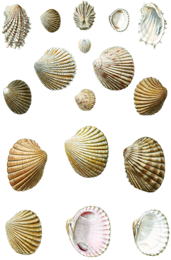
Picture of Carditidae

Credit
W.H.Baily
Licence
Public Domain
Commercial use
the licence allows it

No 3D scan of Carditidae was found in MorphoSource and Sketchfab.

Smithsonian Open Access was not reached for this taxon, so this list is what the others held rather than everything there is.

The description on this site

Licence
CC BY-SA 4.0

This is what the site found, which is not the same as what exists.

Keep going

Occurrence data from the Paleobiology Database, CC BY 4.0. Fleming 1820