Amiidae
The Amiidae are a family of basal ray-finned fishes. The bowfin and the eyespot bowfin are the only two species to survive today, although additional species in all four subfamilies of Amiidae are known from Jurassic, Cretaceous, and Eocene fossils.

Uncredited · via Wikipedia/Commons. May be a photograph of a specimen, or an artist’s reconstruction — an interpretation of a skeleton, since colour and soft tissue are almost never preserved.
On record
Recorded, not inferred- Sits inside
- AmioideiPBDB
- Diet
- carnivore, piscivorePBDB, for Amiiformes
- Life habit
- nektobenthicPBDB, for Amiiformes
- Motility
- actively mobilePBDB, for Amiiformes
Time the record covers
At least 236 million years on record.
The record covers at least 237 Mya to 11.7 ka. No occurrence read is dated outside 239.48 Mya to 0 Mya.
553 occurrences of Amiidae on record, most of them in the Late Cretaceous. The Paleobiology Database records this as a living group. Bar height is expected occurrences, not a count: each fossil is spread across the span it is dated to, so a tall narrow bar means tight dating and a low wide one means loose.
When
553 occurrences- Middle Triassicunder 1%
- Late Jurassic2%
- Early Cretaceous8%
- Late Cretaceous66%
- Paleocene5%
- Eocene14%
- Oligoceneunder 1%
- Miocene3%
- Pleistocene1%
- Holoceneunder 1%
These are dates about fossils, not the animal: the record can only begin after it arose and end before it died out, so either end may reach further. Shares are expected occurrences: a fossil dated to a span is counted partly in each period it straddles. More on what this infers.
Found in
141 formations
- Hell Creek Formation · Montana Group134
- Dinosaur Park Formation · Belly River Group35
- Ferris Formation28
- Lance Formation26
- Willwood Formation16
- Oldman Formation · Belly River Group14
Loading coastlines…
The named rock units Amiidae has been recovered from, largest first. Drawn where the rock is now, not where it formed. 117 further formations hold fewer occurrences each and are not listed. 37 occurrences have no formation on record, which is common for older literature.
Amiidae and its relatives
Late CretaceousWhere Amiidae and its relatives were recorded in the Late Cretaceous.
Found in the same rock
2,271 taxa- Trionychidae110 sites
- Myledaphus bipartitus104 sites
- Scapherpeton tectum100 sites
- Lepisosteus occidentalis92 sites
- Ceratopsidae86 sites
- Baenidae84 sites
- Teleostei74 sites
- Champsosaurus72 sites
- Chelydridae69 sites
- Hadrosauridae69 sites
- Lepisosteus69 sites
- Opisthotriton kayi69 sites
- Theropoda64 sites
- Anura63 sites
- Crocodylia61 sites
- Cyclurus fragosus61 sites
- Adocus57 sites
- Borealosuchus sternbergii55 sites
- Belonostomus longirostris54 sites
- Brachychampsa montana54 sites
- Paronychodon54 sites
- Paralbula casei50 sites
- Compsemys victa48 sites
- Aves47 sites
The Paleobiology Database records 462 sites for Amiidae, and this reads 240 of them. The number is how many of those sites it was catalogued from too. The 24 sharing the most are listed.
This is not a list of everything alive at the time. It is only what has come out of the same ground as this animal and been written down.
Entered from
224 references- Vertebrate biostratigraphy of the Hell Creek Formation in southwestern North Dakota and northwestern South Dakota49
- Fossil Vertebrate Collections35
- Vertebrate faunal changes through Lancian and Puercan time in southern Wyoming30
- A new genus and species of Amiidae (Holostei; Osteichthyes) from the Late Cretaceous of North America, with comments on the phylogeny of the Amiidae24
- Patterns of geographic variation in latest Cretaceous vertebrates: evidence from the turtle component23
- Paleontology of the Judith River Formation (Campanian) of Dinosaur National Park, Alberta, Canada: evidence from vertebrate microfossil locality19
- Vertebrate microsite assemblages (exclusive of mammals) from the Foremost and Oldman Formations of the Judith River Group (Campanian) of southeastern Alberta: an illustrated guide13
- Paleoecology of an estuarine, incised-valley fill in the Dinosaur Park Formation (Judith River Group, Upper Cretaceous) of southern Alberta, Canada13
- Fossil vertebrates from the Late Cretaceous Lance Formation, eastern Wyoming13
- Stratigraphy and mammalian paleontology of the McCullough Peaks, northern Bighorn Basin, Wyoming: Implications for biochronology, basin development, and community reorganization across the Paleocene-Eocene boundary12
- Non-marine fishes of the late Santonian Milk River Formation of Alberta, Canada – evidence from vertebrate microfossil localities7
- Vertebrates of the Iron Springs Formation, Upper Cretaceous, southwestern Utah7
Each of the 553 occurrences read was entered from one of these publications, ordered by how many each accounts for. This is not a search for papers mentioning the name. 212 further references are not listed. Entries link to doi.org where the Paleobiology Database holds an identifier, and to its own record where it does not. Relayed as the Paleobiology Database holds them, not checked against what they resolve to.
Media and terms
Media content1
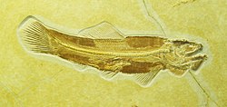
Picture of Amiidae
- Source
- Wikipedia/Commons
- Credit
- nobody named on the record
- Licence
- not stated by the source
- Commercial use
- cannot be read from the licence given — check the record
No 3D scan was found. Smithsonian Open Access, MorphoSource and Sketchfab were all searched.
The description on this site
- Source
- Wikipedia, “Amiidae”
- Licence
- CC BY-SA 4.0
This is what the site found, which is not the same as what exists.
Keep going
What may have been alongside itAmioidei through timeFormations of the Late CretaceousThe world it lived on
Occurrence data from the Paleobiology Database, CC BY 4.0. (Huxley 1861)